Mt. Whitney Climb
I used to keep a journal when I was younger. The following is my journal entry about my climb of Mt. Whitney. It was actually written the day after, but I wrote it as if it was the day of the climb. I did the climb on Saturday, September 16, 1978 when I was 34 years old.
![]()
Climbed Mt. Whitney today! Drove to Lone Pine last night but couldn’t find a room. Spent the night in a campground and got up early. Had to get gas so I didn’t get started at the Mt. Whitney Portal parking lot until 8:30am. Approximately 8,300 feet at the start. Didn’t take a pack because of the weight and I only planned to take a day (hope-hope!). Actually I made up my mind that if it looked like I couldn’t make the top and get back down by night I’d turn around. Took boots, gaiters, sweater, wool shirt, sunglasses, walking stick, wool pants, blue jeans, parka, gorp, gloves, cup, map and wool cap. Didn’t use gloves or parka but could have used suntan lotion.

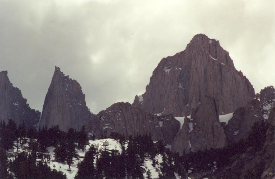
[View of Mt. Whitney taken from the Whitney Portal Rd., east of the campground.]
Trail was always up but not too bad. Some rough spots compared to Yosemite. Stream fording was crude in most spots.
Made the 10,000 foot point no-sweat. On the map it’s called Bighorn Park – a wet sandy meadow with a stream through it. Trail goes up past Mirror Lake and gets rougher as it approaches Consultation Lake. Slightly above Consultation Lake is Trail Camp, the final camp area, at about 12,000 feet. Above tree line now and just below snow line. Stream thunders through this camp area (to the side of it anyway). This is where the trail really begins.

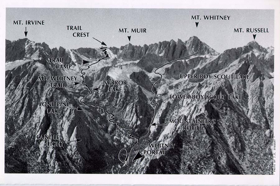
[East side of Mt.
Whitney showing the trail from Whitney Portal to the summit.
I followed
the trail on the left. A topo of the trail is
here.]
Ah, also met a German couple at a small meadow between Mirror Lake and Consultation Lake – they were a the foot of the switchback trail above Consultation Lake having a snack when I got there. Stopped to talk and shared a grapefruit with them (theirs). Karl & Marie. We decided to make the ascent together. About 200 feet up, the switchback trail was covered with snow. There had been snow signs earlier but the trail was clear. The climbing became more tricky. The slope was very steep (that’s why the switchback trail) and the trail’s narrow – worse with the snow. There were two bad points. The first was sort of under an overhang where water had dripped onto the trail and frozen, then covered over with snow. The second was a slope where the trail was completely covered and we had to kick a traverse across the snow slope. This was the worse time for me. I would visualize the footing giving way and me going sliding on my face down the slope – with my chin bouncing off a rock every now and again. I didn’t like to think about coming down either, having to descend this area. I almost turned around at this point but Karl and Marie seemed to know what they we doing and by example, I followed. If I had been alone, I probably would have turned around.
The climbing was hard now. Karl and Marie were in magnificent physical condition and really sped along. Words can’t describe the feeling of that climb. I felt like I was barely hanging in there. The climb was from 12,000 feet to 13,500 feet.

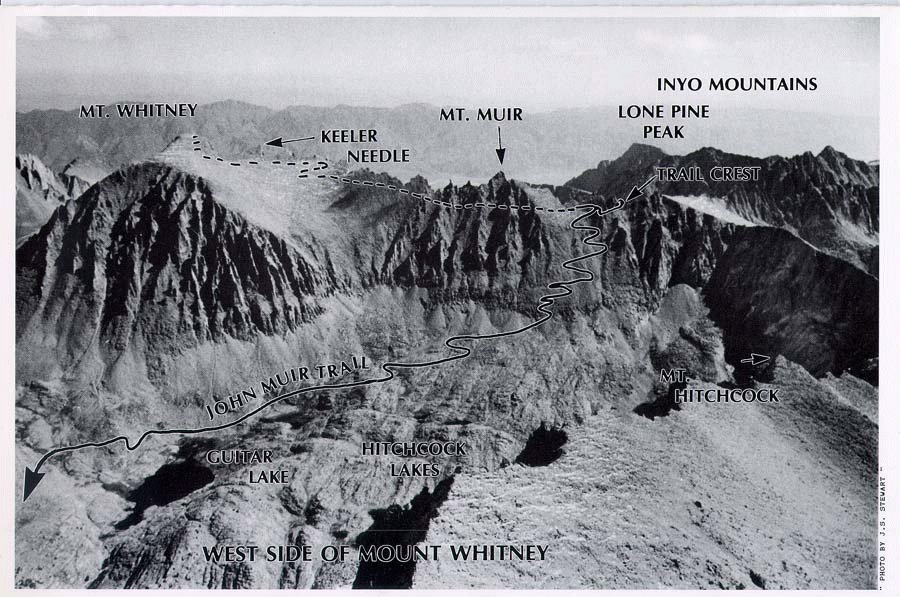
[West side of Mt.
Whitney showing the west valley and the summit trail to Mt. Whitney.
It's
quite a view from the trail crest.]
But finally we saw the trail crest and people sitting there. I pushed on and flopped down on the crest. What a view! What a sight! To the east was the valley we had come up with the lakes and trail and trees and snow – all the way to the valley where Lone Pine is. To the west, a steep drop off into a valley with two lakes and more mountains in the distance. Silently we each asked ourselves if we wanted to go on. Whitney is 14, 494 feet and we were at 13,500. Also there were about two miles of trail distance to go. After resting we all felt better and decided to go on. We had a snack, ate some snow, and I put on my gaiters. The snow was deep on the crest – several feet in places where I pushed my walking stick, probably only a few inches on the packed trail. The trail went down to the junction point of the Muir trail and the Whitney trail and the going was easy. Karl and Marie were pushing on with no pain and were far in front of me. At first, I pushed on steadily but slowly. Met Tom, an Oriental guy who was having a worse time of it than I was and we discussed how weak we felt in the 14,000 foot altitude. You have no strength. You don’t really hurt – you just feel as if you can’t go on. Walking is so hard – resting is so nice.
I left Tom behind and pushed on. I passed some people and some passed me. We all felt the same, however. Some just had a bit more endurance than others.
Two miles to the summit. It felt like a hundred. I don’t really remember any specific parts – just pushing myself on.
Finally, a guy was coming down and said, “About 150 yards more and you can see the shelter.” I rested on a rock to gather strength. The sky was very deep blue, almost black through the Polaroid glasses. Very clear day – almost no clouds except for a few wisps to the north. It was hot.

[Here's a view
approaching the summit, showing the shelter built there.
Here's some other pictures from the
Whitney trail.]
I pushed on and the ground became less steep. I could see the roof of the shelter – I could see the top! And Karl and Marie sitting on a rock having a snack. I staggered up to the shack to look around and found the sign-in log. Boy, did I sign in! Then over to Karl and Marie and shouts of joy. Karl hands me a half full gallon of Scotch! And a Budweiser! Not only had this crazy German been racing up the trail, he had been carrying all this "stuff".
I took a hard pull from the Scotch and accepted the Bud from Karl. They also insisted that I take a bread roll and some cheese. It got a bit colder on top so I put the wool shirt on.
There were about 10 – 12 people on top and we were laughing and carrying on. Shooting the breeze and taking pictures. Tom made it to the top and joined us. Someone had a pint of peach brandy and Karl pulled out the Scotch bottle again and we all had another round. At least four of the group were women.

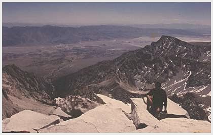
[Here's a view from the summit looking down towards Lone Pine.]
I made it to the top at 2:30pm. Karl and Marie had made it about 2 and we decided to leave at 3:30. We had 10.5 miles to go to the parking lot and 6,000 feet to descend.
I followed Karl and Marie again. The place where we traversed on the way up was not looking good so we decided to glisslide down to the next level on the trail. I was scared to death. I could see myself glissliding past the next trail level and down the rest of the slope. I sat down on the upper trail, dug my heels in, put my walking stick under my left armpit and pushed off, aiming for an outcropping rock so that I could grab on to something if I started glissliding out of control. And down I went, from rock to rock ‘till I reached the next trail level. Looking back up, it was fun. I’d like to do it again on a slope with a good runout and several hundred feet to glisslide.
Karl, as usual, was ahead and had set up a snack at 12,000 feet by the time Marie and I got there. This time they pulled out a quart and a half of white wine and cookies!! Amazing! I had a short cup of wine and two cookies and took off telling them I needed a head start to be able to keep up with them.
I was bouncing down feeling great, telling everyone coming up how bad the trail was. Karl and Marie caught me at the 10,000 foot level. Another guy was with them and I was able to keep up with them for a while.
It was now getting late and the sun was setting. My feet were starting to hurt. I had blisters on both big toes, especially bad on my right toe (you know how you can feel the skin moving on a bad blister) and some rubbed sore spots on my right heel and ankle. There was no way to think of stopping now – the sky was getting dark and there was much trail to go.
Karl and Marie were way in front of me and I was pushing on as hard as I could – really hurting now. The trail just went on forever. I knew that when the trail turned to the north side of the valley we would be on the final leg. I kept looking for the trail to turn but it kept switchbacking on the west side of the valley. Finally it turned. Then came the streams I had remembered fording and the final turn and downslope to the parking lot.
Karl and Marie and the other guy were down and having a glass of orange juice at their car. Karl pushed a glass into my hand. I hurt all over. My blisters had blisters. My legs ached. It was 8pm or 8:30pm, I really don’t remember. I had wanted to take Karl and Marie to dinner but it was impossible now.
We said our goodbyes.
It was pitch dark and I didn’t know exactly where my car was, so the other guy said he’d give me a ride to it. He had a VW bus and I was so tired and sore I almost couldn’t climb into it. He dropped me at my car and we said our goodbyes. I peeled off my boots, socks, and wool pants and stashed everything in the car.
I was determined to get a shower and bed. The last of either was Monday night before I left. Lone Pine was full so I drove south ‘till I found the “Sportsman Motel” and for $10.50 got a room(?) and shower. Cooked soup and chili on the pack stove after a shower and fell into bed. Slept badly. Dreaming of the trails along the crest and of falling off.
[My journal entry ends here. The trail distance up and back is 21 miles (about 10.5 miles each way). It's a bit over 6,000 feet from the parking lot to the summit.]